Results
Q1. EGNOS provides a WAAS by determining the errors in……. and broadcasting these errors to receivers using……
Q2. What is an ADC input to the FMC?
Q3. On an EFIS display the pictured symbol represents:
Q4. An aircraft GNSS receiver is using 5 satellites for RAIM. If the receiver deselects one satellite then the flight should be continued:
Q5. What function does the course line computer perform?
Q6. The frequency band of the NAVSTAR/GPS L1 and L2 frequencies is:
Q7. The phantom station in a 2D RNAV system may be generated by:
Q8. An ‘all in view’ satellite navigation receiver is one which:
Q9. The function of the receiver in the GNSS user segment is to:
Q10. If sink rate is excessive the GPWS indication will be?
Q11. When is the FMS position likely to be least accurate?
Q12. The GPWS would provide visual and audible warning to a pilot if the aircraft descended:
Q13. Which of the following statements concerning ionospheric propagation errors is true?
Q14. In NAVSTAR/GPS range measurement is achieved by measuring:
Q15. If the signal from an SV is lost during an aircraft manoeuvre:
Q16. In NAVSTAR/GPS the space segment:
Q17. Unauthorized’ civilian users of NAVSTAR/GPS can access:
Q18. Concerning NAVSTAR/GPS orbits, which of the following statements is correct?
Q19. In GPS on which frequencies are both the C/A and P codes transmitted?
Q20. When flying under IFR using GPS and a multi-sensor system:
Q21. On the B737-400 EHSI what happens if the selected VOR fails?
Q22. The FMC position is:
Q23. The inclination of a satellite is:
Q24. The indications from a basic RNAV are behaving erratically. The reason is likely to be:
Q25. The cause of a RNAV giving erratic readings would be:
Q26. The track line on an EFIS display indicates:
Q27. The purpose of the PRN codes in NAVSTAR/GPS is to:
Q28. Comparing the L1 and L2 signals helps with the reduction of which GNSS error?
Q29. The contents of the navigation and systems message from NAVSTAR/GPS SVS include:
Q30. In an RNAV system which combination of external reference will give the most accurate position?
Q31. The FMS database can be:
Q32. Selective availability may be used to degrade the accuracy of the NAVSTAR/GPS position. This is achieved by:
Q33. The MDA for a non-precision approach using NAVSTAR/GPS is based on:
Q34. The NAVSTAR/GPS space segment:
Q35. The RNAV function of the FMC produces a position which:
Q36. Which input to the FMC is taken from sources external to the aircraft?
Q37. The inputs the pilot will make to the FMC during the pre-flight initialization will include:
Q38. In NAVSTAR/GPS the PRN codes are used to:
Q39. According to ICAO (Annex 11), the definition of an RNAV system is:
Q40. The best position on an aircraft for the GNSS aerial is:
Q41. The preferred GNSS receiver for airborne application is:
Q42. The task of the control segment is to:
Q43. With reference to GPWS:
Q44. In GNSS a fix is obtained by:
Q45. Which of the following external inputs is required by the FMC to determine W/V?
Q46. What information can a GPS fix using four satellites give you?
Q47. The distance measured between a satellite and a receiver is known as a pseudo-range because:
Q48. The skysearch carried out by a GNSS receiver:
Q49. For the FMC the take-off speeds, V1, VR and V2 are found:
Q50. The optimum cruise speeds used by the FMC are found:
Q51. The ETA generated by the FMS will be most accurate:
Q52. Which of the following can be input manually to the FMC using a maximum of 5 alphanumerics?
Q53. The visibility of GPS satellites is:
Q54. When using GPS to fly airways, what is the vertical reference used?
Q55. Using differential GNSS for a non-precision approach, the height reference is:
Q56. The principle error in GNSS is:
Q57. In the B737-400 EFIS which component generates the visual display?
Q58. The colour used on the B737-400 EHSI weather display to show turbulence is:
Q59. The inputs to the EHSI display during automatic flight include:
Q60. Which of the following is independent of external inputs?
Q61. Which of the following statements concerning differential GPS (DGPS) is true?
Q62. The azimuth and elevation of the satellites is:
Q63. In NAVSTAR/GPS the PRN codes are used to:
Q64. The FMC position is:
Q65. During flight using NAVSTAR/GPS and conventional navigation systems, you see a large error between the positions given by the systems. The action you should take is:
Q66. The navigation database in an FMC:
Q67. The NAV and system data message is contained in the…….signal.
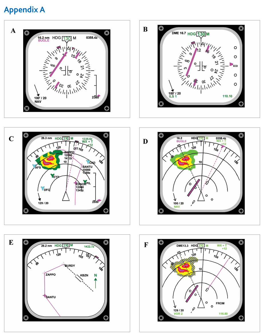
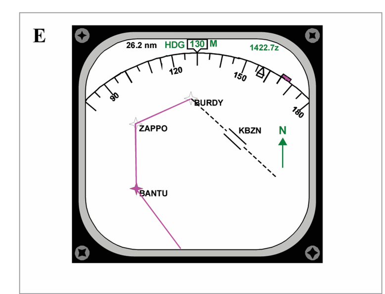
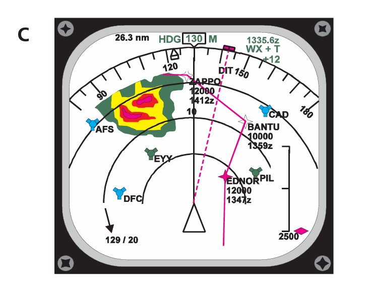
Q68. Refer to Appendix A. Which diagram shows the MAP display?
Q69. When midway between two waypoints, how can the pilot best check the progress of the aircraft?
Q70. How is the distance between the NAVSTAR/GPS SV and the receiver determined?
Q71. If the signal from a VOR is lost, how is this shown on the B737-400 EHSI display?
Q72. RAIM is achieved:
Q73. The operation of a 2D RNAV system may be seriously downgraded:
Q74. In a RNAV system the DME is tuned:
Q75. When is the IRS position updated?
Q76. The almanac in the receiver:
Q77. Which of the following is true concerning the use of GNSS position in the FMC?
Q78. The accuracy required of a basic area navigation (B-RNAV) system is:
Q79. NAVSTAR GPS receiver clock error is removed by:
Q80. The height derived by a receiver from the NAVSTAR/GPS is:
Q81. The WGS84 model of the earth is:
Q82. The GPWS the alert/warning information is provided by a radio altimeter with:
Q83. At what radio altitude is Mode 4 armed?
Q84. The orbits of the NAVSTAR GPS satellites are inclined at:
Q85. GPWS mode 3 will operate if altitude loss occurs before you have acquired:
Q86. When using a two dot HSI, a deviation of one dot from the computed track represents approximately:
Q87. The NAVSTAR/GPS constellation comprises:
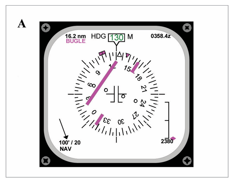
Q88. Refer to Appendix A, diagram A. What is the deviation from the required track? (visual Q.)
1 DOT = 2 NM IN VOR MODE
Q89. An aircraft, using a 2D RNAV computer, is 12 NM from the phantom station, 25 NM from the VOR/DME designating the phantom station and the phantom station is 35 NM from the VOR/DME. The range read-out in the aircraft will be:
Q90. The NAVSTAR/GPS constellation comprises:
Q91. The Ground Proximity Warning mode 4A provides a visual and audible warning ‘Too Low Gear’ to the pilot if the aircraft descends below _ _ _ _ _ _ with landing gear retracted.
Q92. An aircraft ‘goes around’ after descending to a radio alt of 190 feet. As power is applied a power unit is lost and some height is lost. The GPWS would provide an alert when the aircraft had lost about:
Q93. In RNAV mode one dot on the EHSI represents:
Q94. If the receiver almanac becomes corrupted it will download the almanac from the constellation. This download will take:
Q95. Which of the following are GPWS modes? 1. Approaching stall. 2. Excessive glide slope deviation. 3. Excessive ROC. 4. Excessive ROD. 5. Incorrect flap position. 6. Sinking after lift-off and during go-around. 7. High altitude descent.
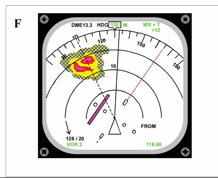
Q96. Refer to appendix A, diagram F. What is the required track? (visual Q.)
Q97. Which GPS frequencies are available for commercial air transport?