Results
Q1. What is the wavelength corresponding to a frequency of 375 kHz?
Q2. Which wavelength corresponds to a frequency of 5035 MHz?
Q3. What is the maximum PRF that allows detection of targets to a range of 50 km? (ignore any flyback time).
Q4. The Doppler effect is:
Q5. Primary radar operates on the principle of:
Q6. The definition of a radar display will be best with:
Q7. The Main advantage of a continuous wave radar over a pulsed radar is:
Q8. Which of the following systems use pulse technique? Which of the following systems use pulse technique? 1. secondary surveillance radar 2. airborne weather radar 3. distance measuring equipment 4. primary radar
Q9. To double the range of a primary radar, the power must be increased by factor of:
Q10. In a primary pulsed radar the ability to discriminate in azimuth is a factor of:
Q11. The maximum range of a ground radar is limited by:
Q12. What does pulse recurrence rate refer to?
Q13. The maximum PRF required for a range of 50 NM is:
Q14. The best radar for measuring very short ranges is:
Q15. Which is the most suitable radar for measuring short ranges?
Q16. The main advantage of a slotted scanner is:
Q17. The Maximum unambiguous range for a PRF of 1200 pps is:
Q18. PRF 450 pps. Speed of light 300,000 km/s. Max range?
Q19. The best picture on a primary radar will be obtained using:
Q20. Which of the following is a primary radar system?
Q21. On what principle does primary ATC radar work?
Q22. The type of radar which has no minimum range restriction is:
Q23. The maximum theoretical range of a radar is determined by:
Q24. The time interval between the transmission of a pulse and receipt of the echo from a target is 925.5 microseconds. The range of the target is:
Q25. An advantage of a slotted antenna (planar array) over a parabolic reflector are:
Q26. The best resolution will be achieved on a radar display with:
Q27. A radar transmitting on 600 MHz has a PRF of 300 pps and an aerial rotation rate of 5 rpm. This radar will be:
Q28. The airborne weather radar (AWR) cannot detect:
Q29. The frequency of AWR is:
Q30. The use of the AWR on the ground is:
Q31. Which type of cloud does the AWR detect?
Q32. The AWR uses the cosecant squared beam in the …………… mode.
Q33. On the AWR display the most severe turbulence will be shown:
Q34. On an AWR colour display, the sequence of colours indicating increasing water droplet size is:
Q35. In an AWR with a 5° beamwidth, how do you orientate the scanner to receive returns from clouds at or above your level?
Q36. The ISO-ECHO circuit is incorporated in the AWR:
Q37. The main factors which affect whether an AWR will detect a cloud are:
Q38. In an AWR with a colour CRT, areas of greatest turbulence are indicated by:
Q39. As a storm intensifies, the colour sequence on the AWR display will change:
Q40. The cosecant squared beam is used for mapping in the AWR because:
Q41. The AWR can be used on the ground provided: 1. the aircraft is clear of personnel, buildings and vehicles 2. conical beam is selected 3. maximum uptilt is selected 4. the AWR must never be operated on the ground
Q42. Doppler navigation systems use …………… to determine the aircraft ground speed and drift.
Q43. Which axes is the AWR stabilized in?
Q44. The AWR operating frequency is:
Q45. The AWR frequency is selected because it gives:
Q46. On a colour AWR display, the heaviest precipitation will be displayed in:
Q47. With normal SSR mode C altitude coding the aircraft replies by sending back a train of up to 12 pulses contained between 2 framing pulses with:
Q48. Why is the effect of returns from storms not a problem with SSR?
Q49. The advantages of SSR mode S are:
Q50. The accuracy of SSR mode C altitude as displayed to the air traffic controller is:
Q51. The SSR ground transceiver interrogates on ……………. and receives responses on …………….
Q52. The vertical position provided by SSR mode C is referenced to:
Q53. Why is a secondary radar display free from weather clutter?
Q54. The availability of 4096 codes in SSR is applicable to mode:
Q55. With reference to SSR, what code is used to indicate transponder altitude failure?
Q56. The SSR code to select when the aircraft is being unlawfully interfered with is:
Q57. In SSR the ground station interrogates the aircraft…… on MHz and receives replies from the aircraft on……… MHz
Q58. The altitude read-out at the ground station from a mode C response will give the aircraft altitude within:
Q59. What happens when a DME in the search mode fails to achieve lock-on?
Q60. The Most accurate measurement of speed by DME for aircraft at 30,000 ft will be when the aircraft is :
Q61. A DME beacon will become saturated when more than about … aircraft are interrogating the transonder.
Q62. A typical DME frequency is:
Q63. The DME in an Aircraft, cruising at FL210, fails to achieve lock-on DME at MSL at a range of 210 NM. The Reason for this is:
Q64. The Aircraft DME receiver accepts replies to own transmissions but rejects replies to other aircraft transmissions because:
Q65. When an Aircraft at FL360 directly above DME , at mean sea level, the range displayed will be:
Q66. A DME frequency could be:
Q67. An Aircraft at FL360 is 10 NM plan range from a DME. The DME reading in the aircraft will be:
Q68. A DME transceiver does not lock onto its own reflections because:
Q69. What information does military TACAN provide for civil aviation users?
Q70. The DME in an aircraft flying at FL430 shows a range of 15 NM from beacon at elevation of 167 ft. The Plan range is:
Q71. What are the DME frequencies?
Q72. The Time from the transmission of the interrogation pulse to the receipt of reply form the DME ground station is 2000 microseconds. ( ignore the delay at the DME ). The Slant range is:
Q73. The DME counters are rotating continuously. This indicates that:
Q74. On a DME presentation the counters are continuously rotating. This indicates:
Q75. An aircraft at FL200 is 220 NM from a DME at MSL. The aircraft equipment fails to lock on to the DME. This is because:
Q76. A typical frequency for DME would be:
Q77. If the aircraft DME interrogates a ground transponder on a frequency of 1199 MHz, it will look for replies on:
Q78. A DME recognizes replies to its own interrogating pulses because:
Q79. The DME in an aircraft at FL630 measures a slant range of 16 NM from a ground station at 1225 ft AMSL. The plan range is:
Q80. In an RNAV approach phase with a two dot lateral deviation HSI display, a one dot deviation from track would represent:
Q81. The required accuracy of a precision RNAV (P-RNAV) system is:
Q82. The ETA generated by the FMS will be most accurate:
Q83. When is the FMS position likely to be least accurate?
Q84. For position fixing the B737-800 FMC uses:
Q85. When using a two dot HSI, a deviation of one dot from the computed track represents approximately:
Q86. An aircraft, using a 2D RNAV computer, is 12 NM from the phantom station, 25 NM from the VOR/DME designating the phantom station and the phantom station is 35 NM from the VOR/DME. The range read-out in the aircraft will be:
Q87. The FMC position is:
Q88. When midway between two waypoints, how can the pilot best check the progress of the aircraft?
Q89. Which of the following can be input manually to the FMC using a maximum of 5 alphanumerics?
Q90. The inputs to the EHSI display during automatic flight include:
Q91. The inputs the pilot will make to the FMC during the pre-flight initialization will include:
Q92. In RNAV mode one dot on the EHSI represents:
Q93. The phantom station in a 2D RNAV system may be generated by:
Q94. The operation of a 2D RNAV system may be seriously downgraded:
Q95. The navigation database in the FMS:
Q96. In an EHSI the navigation information comes from:
Q97. On an EFIS display the pictured symbol represents:
Q98. According to ICAO (Annex 11), the definition of an RNAV system is:
Q99. Which of the following is independent of external inputs?
Q100. The track line on an EFIS display indicates:
Q101. The EHSI is showing 5° fly right with a TO indication. The aircraft heading is 280°(M) and the required track is 270°. The radial is:
Q102. On the B737-400 EHSI what happens if the selected VOR fails?
Q103. In an RNAV system which combination of external reference will give the most accurate position?
Q104. If the signal from a VOR is lost, how is this shown on the B737-400 EHSI display?
Q105. The colour used on the B737-400 EHSI weather display to show turbulence is:
Q106. The cause of a RNAV giving erratic readings would be:
Q107. The accuracy required of a basic area navigation (B-RNAV) system is:
Q108. What function does the course line computer perform?
Q109. What is an ADC input to the FMC?
Q110. The indications from a basic RNAV are behaving erratically. The reason is likely to be:
Q111. In a RNAV system the DME is tuned:
Q112. Which input to the FMC is taken from sources external to the aircraft?
Q113. For the FMC the take-off speeds, V1, VR and V2 are found:
Q114. The optimum climb and descent speeds used by the FMC are found:
Q115. The optimum cruise speeds used by the FMC are found:
Q116. Which of the following external inputs is required by the FMC to determine W/V?
Q117. Which of the following is true concerning the use of GNSS position in the FMC?
Q118. A 2D RNAV system takes fixing inputs from:
Q119. The accuracy required of a basic RNAV system is:
Q120. An aircraft using a 2D RNAV system is 23 NM from the waypoint on a 50 NM leg. The waypoint is 45 NM from the VOR/DME and the aircraft is 37 NM from the VOR/DME. The range indicated to the pilot will be:
Q121. The navigation database in an FMC:
Q122. The RNAV function of the FMC produces a position which:
Q123. The most accurate external reference position will be provided by:
Q124. The FMC position is:
Q125. The FMS database can be:
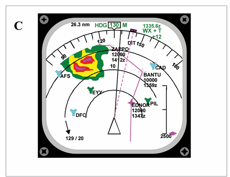
Q126. Refer to Appendix A diagram C. What is the current drift? ( visual Q )
Q127. In the B737-400 EFIS which component generates the visual display?
Q128. When is the IRS position updated?
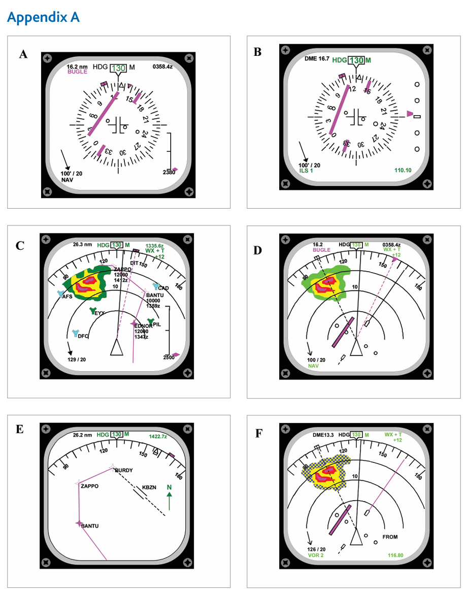
Q129. Refer to Appendix A. Which diagram is the MAP mode? (visual Q.)
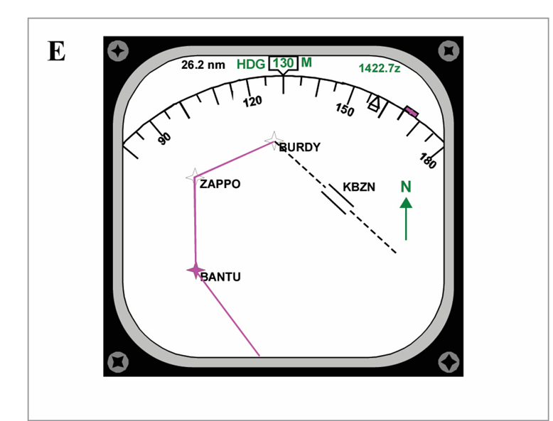
Q130. Refer to diagram E of Appendix A. The track from ZAPPO to BURDY is: (visual Q.)
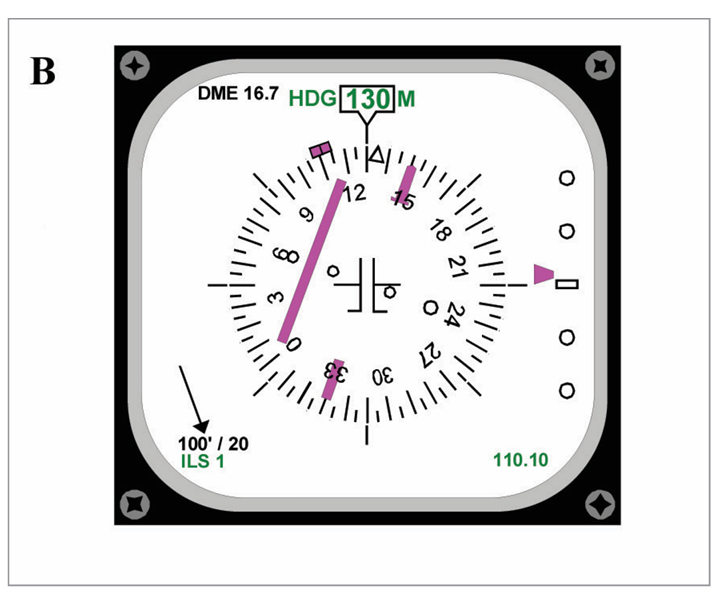
Q131. Refer to diagram B of Appendix A. The aircraft is: (visual Q.)
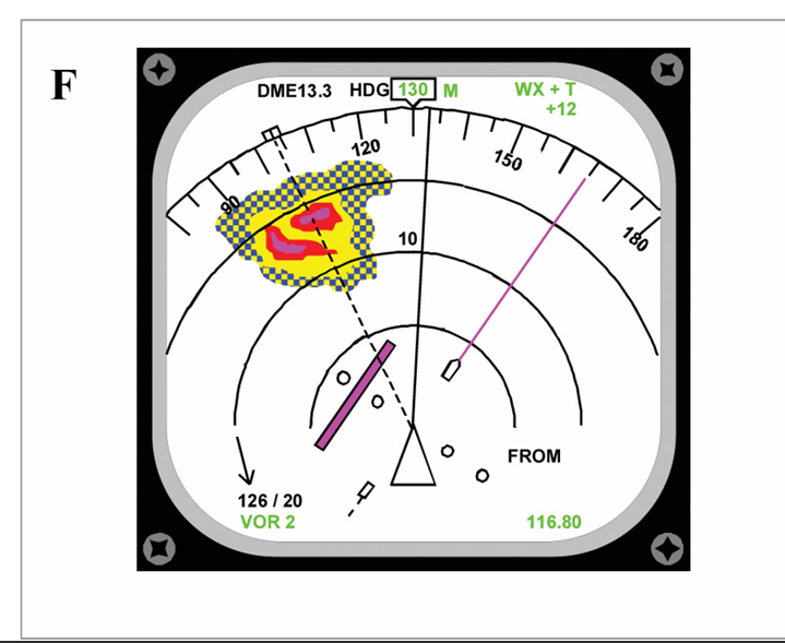
Q132. Refer to Appendix A. Diagram F represents: (visual Q.)
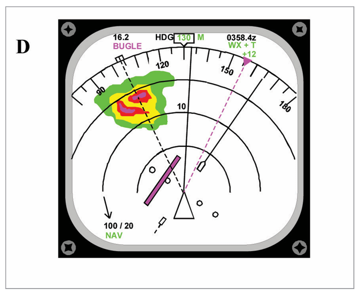
Q133. Refer to diagram D of Appendix A. The current aircraft track is: (visual Q.)
Q134. Refer to appendix A diagram C. The wind velocity is:
Q135. In order that a waypoint designated by a VOR can be used by a RNAV system:
Q136. Which EHSI modes cannot show AWR information?
Q137. Refer to appendix A, diagram C. The symbol annotated KXYZ is: (visual Q.)
Q138. Refer to Appendix B. The distance displayed on the EHSI will be: (visual Q.)
Q139. Refer to Appendix A. Which diagram shows the MAP display?
Q140. Refer to Appendix A, diagram E. What is the track from BANTU to ZAPPO? (visual Q.)
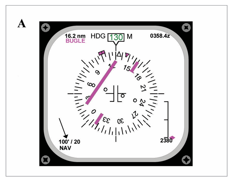
Q141. Refer to Appendix A, diagram A. What is the deviation from the required track? (visual Q.)
Q142. Refer to appendix A, diagram F. What is the required track? (visual Q.)